

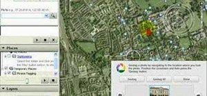
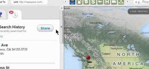
Google Earth is a virtual globe application, that you can use to view the Earth, either as a satellite image, a series of aerial photographs, or a superimposed combination of the two.
When sorting your photos in Picasa, you can automatically add Geotag information to them, by using Google Earth to locate the exact position on the globe where to photo was taken, and in this screencast tutorial, we show you how.
Once you've uploaded your photos to Google Earth, other users will be able to view your photos, simply by clicking on the tag you created.
Just updated your iPhone? You'll find new emoji, enhanced security, podcast transcripts, Apple Cash virtual numbers, and other useful features. There are even new additions hidden within Safari. Find out what's new and changed on your iPhone with the iOS 17.4 update.


Be the First to Comment
Share Your Thoughts